Powered By
NCoDE™ Engine MX100
NCoDE SeaTwin receives all its data from the NCoDE Engine running on the MX100 platform. Every sensor reading, equipment status, and system state flows into the digital twin in real time.
NCoDE SeaTwin creates a sophisticated digital twin that mirrors your vessel's physical and operational status in real time.
Using live data from onboard sensors, equipment, and software integrations, SeaTwin creates a comprehensive virtual model of your vessel that can be accessed from anywhere.
A photorealistic 3D model of your vessel with live data overlays, dynamic water simulation, and interactive controls.
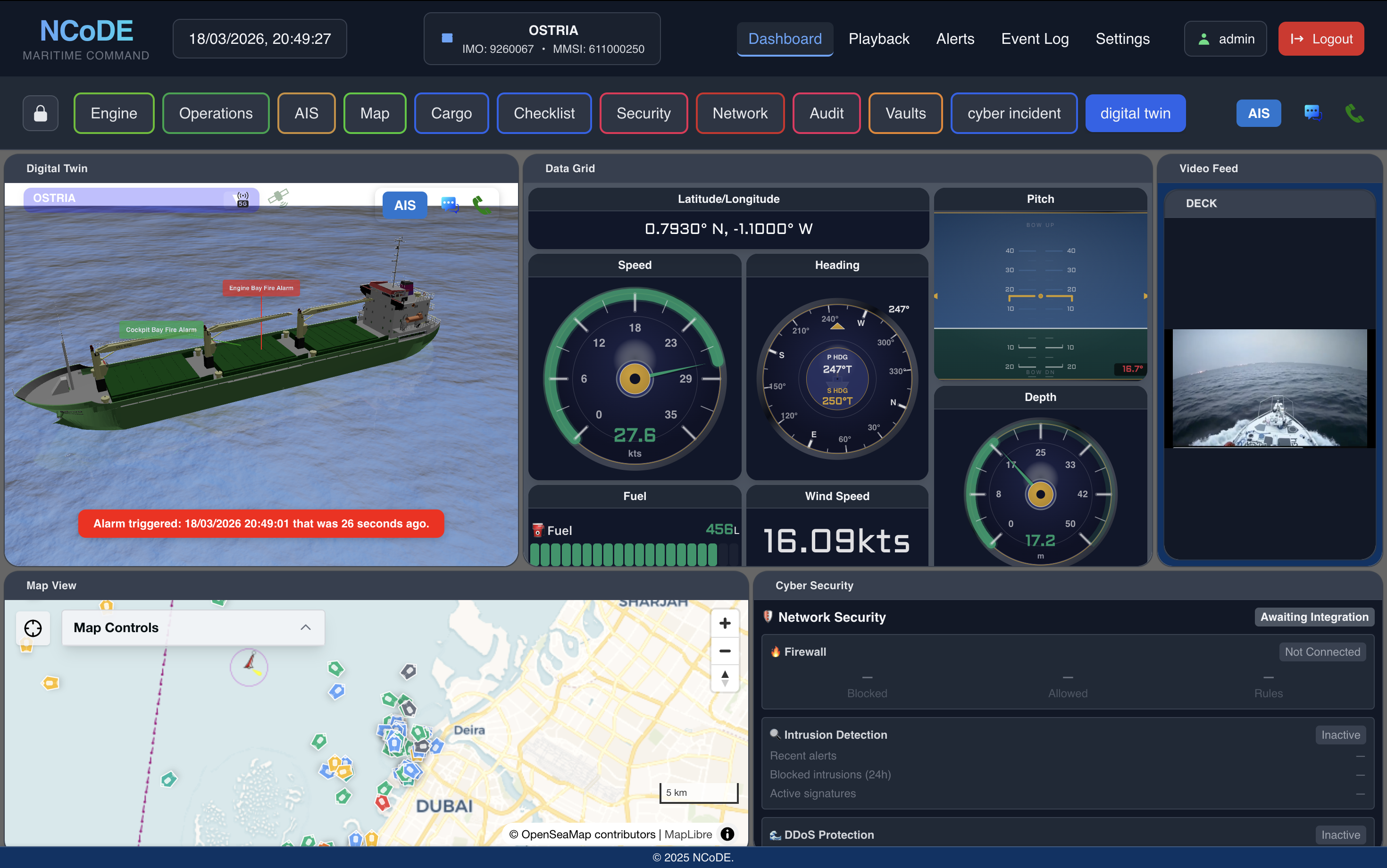
Real-time WebGL vessel model with dynamic water, live HUD overlay showing heading, speed, and navigational status. AIS contacts displayed in 3D space around your vessel.
NCoDE SeaTwin receives all its data from the NCoDE Engine running on the MX100 platform. Every sensor reading, equipment status, and system state flows into the digital twin in real time.
NCoDE SeaTwin aggregates data from every onboard system and presents it through an intuitive visual interface.
Real-time status of engines, generators, battery banks, and power distribution systems.
Live surveillance feeds, door/hatch statuses, motion sensors, and access control events.
Uptime and performance monitoring of satellite, VSAT, 4G/5G, and onboard IT infrastructure.
Weather, location, sea state, onboard temperature, and humidity for voyage planning.
NCoDE SeaTwin is an interactive tool for understanding and managing your vessel, not just a visualisation.
Rotate, zoom, and explore a photorealistic 3D model of your vessel. Click on systems to see detailed status and data.
See nearby vessels in 3D space with AIS data, course predictions, and CPA/TCPA calculations.
Review past voyages and system states. Replay events to understand what happened and when.
See alerts in context. When an alarm triggers, the 3D model highlights the affected system or location.
Historical data and trend analysis for predictive maintenance. Identify patterns before they become problems.
Part of NCoDE Command. SeaTwin is a dashboard view within the unified vessel management platform.
NCoDE SeaTwin transforms complex vessel data into an intuitive visual experience. Understand your vessel's status at a glance with a real-time 3D digital twin.